Use pull down menus above to navigate the site.
|
|
Gelderd Road
 Click on Map to Expand ¹
Before 1826, if one wanted to walk or ride a horse from Gildersome to Leeds, a person had three good options (see map left):
- 1. A footpath out Branch Ave. to a footbridge, then on to
- Morley Hole. Similar to today's Asquith Ave. (red arrow)
- 2 . A footpath from the Griffin Inn past Gilead House to a
- footbridge called Roomsbridge. (green arrow)
- 3. A footpath from the top of Harthill Lane to what was then
- called Mad Dog Lane then to Roomsbridge. (blue arrow)
It wasn't the inconvenience of Gildersome merchants that spurred on the development of a new road, but rather the need for a straighter and more level "Turnpike" from Leeds to Birstall. This had been the subject of discussion for some time. Complaints about the two hills at Churwell and the steep grades at Howden Clough piled up until it was decided that something had to be done. Sometime circa 1813 or 14, the Leeds to Birstall Turnpike Trust was created to study and eventually implement the creation of such a road and on the 19th of September, 1814 the following appeared in the Leeds Mercury²: "NOTICE is hereby given, That Application is intended to be made to Parliament in the next Session for leave to bring a Bill, with all proper and usual Powers therein for making a Turnpike Road, from or near the Town of Gildersome, in the Parish of Batley, in the West Riding of the County of York, to communicate with the Turnpike Road leading from Leeds to Elland, in the said Riding, at or near to a certain Public Bridge, commonly called or known by the Name of Miles Bridge, in the Township of Churwell, within the Parish of Batley aforesaid; and which said intended Road is proposed to pass over and through Lands within the Townships of Gildersome, Morley and Churwell, all within the said Parish of Batley, ----By Order, JOHN CARR
Wakefield, 3rd September, 1814"
The above was part of grand plan called the Leeds to Halifax Turnpike, consisting of two sections, the Birstall to Halifax Turnpike and the Leeds to Birstall Turnpike. The "Leeds" portion would terminate at The Street and would later be called Gelderd Road and the Halifax portion would begin south of The Street. In the same month as the "Notice", above, a survey was submitted by John Crooks and subsequently delivered to John Carr, entitled: "A Book of Reference to a Plan of an Intended Road from Gildersome to Miles Bridge." ³ The plan detailed a new road starting at the Griffin Inn, which ran a similar course to a then existing "footway" past Gilead house to the west and on to Roomsbridge (see number 2 option above). Its intended point of termination was the Wakefield & Bradford Road via Street Lane. It's certain that, at the time, several options were being explored but it was still early days. In June of 1815, a "Meeting of the Proprietors of Estates"⁴ chaired by Watson Scatcherd was called to exhibit the proposed routes and discuss the project, its impacts upon the economy and any possible land appropriations. The project was received favorably and it was resolved that further study was needed as well as regular meetings attended by those concerned.
Time passed and the wheels of Parliament ground slowly. Finally, in May of 1823, approval was granted: "The public will be glad to learn, that the royal assent to the act of Parliament for the long intended new road from Leeds to Birstal, by way of Gildersome, is obtained, and also that the same will be carried into execution this year. ______This road, when completed, will be of great importance to the country it passes through, and to the town of Leeds, particularly the western parts, as it will open into a very valuable coal district, and may be considered one of the best hues (sic) in this part of the country".⁵
19 Apr 1826 Leeds Intelligencer ²
13 Apr 1826 Leeds Intelligencer ²
|
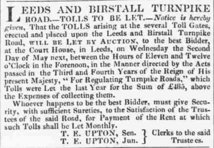
It appears that the construction did begin in the latter half of 1823, as the road's trustees promised. I haven't found a "grand opening" date for the road as a whole so I presume that general use of the road started once a local section was completed. It appears that by the end of 1825, the road had made it all the way to the Wakefield & Bradford Road where it intersects today. The April 1827 advertisement (left) regarding the auction of the right to collect tolls on the new road states that there had been collection in 1826 (see left).
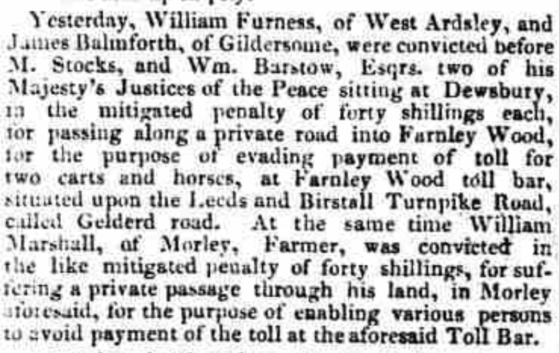
I'm not certain how the road came to be called Gelderd Road. The most likely explanation is that it was named for Mr William Gelderd of Gilead House, Gildersome, a mill owner and owner of a sizable chunk of property through which the road passed. In local newspapers, the first mention of the name Gelderd Road is the April 1826 excerpt (left) regarding toll evaders. In an ironic twist, the 2nd mention concerns an 1827 Highway Robbery of the very man after whom the road got its name (see below). After that, the appearance and use of the name became common. |
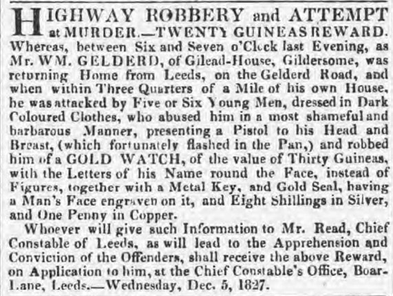
6 Dec 1827 Leeds Intelligencer ²
¹ Public Domain
² © THE BRITISH LIBRARY BOARD. ALL RIGHT RESERVED BritishNewspaper Archive (www.britishnewspaperarchive.co.uk)
³ West Yorkshire Archive Service QE20/2/17
⁴ Leeds Intelligencer 24 Jun 1815 - BritishNewspaper Archive
⁵ Leeds Intelligencer 15 May 1823 - BritishNewspaper Archive
² © THE BRITISH LIBRARY BOARD. ALL RIGHT RESERVED BritishNewspaper Archive (www.britishnewspaperarchive.co.uk)
³ West Yorkshire Archive Service QE20/2/17
⁴ Leeds Intelligencer 24 Jun 1815 - BritishNewspaper Archive
⁵ Leeds Intelligencer 15 May 1823 - BritishNewspaper Archive