Use pull down menus
above to navigate the site.
above to navigate the site.
Gildersome at the Time of the Conquest
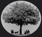
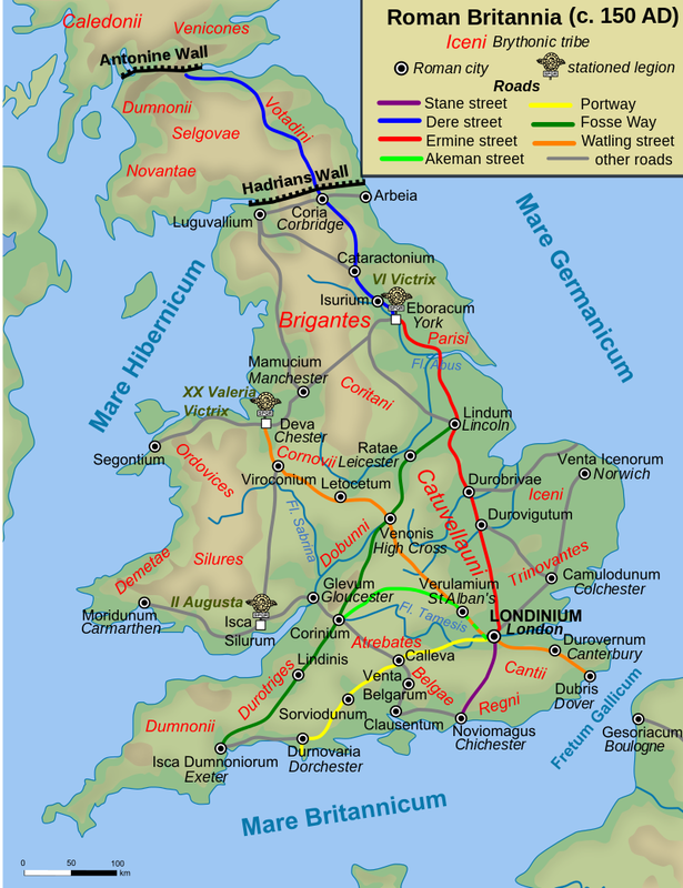
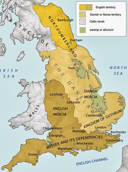
For the sake of this narration, I'm using the name Dean Wood to describe the area within the boundaries of Dean Beck, Farnley Wood Beck, Andrew Beck and the headspring of Howden Clough. See map right. I don't believe that Gildersome, existed as anything of consequence before 1086. There may have been an inn and smithy at the top of Nipshaw Ln. and/or a forester's camp somewhere near the intersection of Branch and Gelderd Rd. Dean Wood was a small part of vast woodland which covered much of West Yorkshire and contained Drighlington's Lumb Wood to the west, Farnley Wood to the north. The area could have been inhabited by a few hardscrabble farmsteads, like the one shown above, nomadic sheep or hog herders who were always on the move, and of course, brigands. Dean Wood had a high water table with abundant springs of fresh water supporting game in abundance such as deer, wild fowl, and wild boar. Harthill commanded a 360 degree view of the area and it's possible it served as a local meeting place or lookout's post. Near the top of Dean Beck, four well traveled "high"roads converged, joining Dean Wood with Leeds, Manchester, Bradford and Wakefield and ancient footpaths crossed through the forest to Leeds, Morley, Drighlington and Farnley. The people living in West Yorkshire at that time had witnessed over 250 years of Viking incursion and occupation. Many of them were descendants of Vikings mixed with Saxon blood and had given up their pagan ways for the christian God. Not too long before 1066, they bowed to the English King and looked forward to a peaceful future. Then came the Normans and with them came a new order. Is Gildersome Implied in the Morley Entry of the Domesday Book? The earliest surviving record of the area is the Morley entry in the Domesday Book. This puts us a mile or so away from Gildersome, see summation right. Morley is recorded as having about 640 cultivated acres, 640 acres "waste" and a woodland, one league by one league. A league at that time is interpreted to be anywhere between 3 miles to 1.4 miles depending on the source. So Morley's valuable woodland can be estimated to have been somewhere between 3,000 acres to 900 acres. Modern Gildersome contains approximately 1,000 acres. Given Dean Wood's proximity to Morley Hole, what could have been more natural than Morley claiming it as its own? If so, it's possible that today's Asquith Ave, and the Dean bridge, in a more primitive form, may have existed in Roman times or earlier. West Yorkshire at the time of the Domesday Book. I think it's important to have a little background on Dean Wood's wider world during that time period. In 1086, the population in West Yorkshire was estimated at less than 3 people per sq mile and most were clustered together in small towns and villages, on flat land near water sources. The following is a description of Leeds circa 1086, from Wikipedia: "Leeds in 1086 had a population of at least two hundred people. Leeds parish is thought to have developed from a large British multiple estate which, under subsequent Anglo-Saxon occupation was further sub divided into smaller land holdings. The ancient parish encompassed Leeds, Headingley, Allerton, Gipton, Bramley, Armley, Farnley, Beeston and Ristone (Wortley). Leeds was the most important of these holdings. Leeds was then further sub divided so that when the first dependable historical record about Leeds (as "Ledes") was written in the Domesday book of 1086, it was recorded as having comprised seven small manors. At the time of the Norman conquest, Leeds was evidently a purely agricultural domain, of about 1,000 acres in extent. It was divided into seven manors, held by as many thanes; they possessed six ploughs (one "plough" is equal to the amount of land a team of 8 oxen with a plough can cultivate in one year, 1 plough = 120 acres); there was a priest, and a church, and a mill: its taxable value was six pounds. When the Domesday records were made, it had slightly increased in value; the seven thanes had been replaced by twenty-seven villains, four sokemen, and four bordars. The villains were what we should now call day-labourers: the soke or soc men were persons of various degrees, from small owners under a greater lord, to mere husbandmen: the bordars are considered by most specialists in Domesday terminology to have been mere drudges, hewers of wood, drawers of water. The mill, when this survey was made, was worth four shillings. There were 10 acres of meadow. The tenant in chief was Ilbert de Lacy to whom William the Conqueror had granted a vast Honour stretching widely across country from Lincolnshire into Lancashire, and whose chief stronghold was at Pontefract Castle, a few miles to the south-east. It was thought that in 1086 Leeds had a population of at least two hundred people." Yorkshire, like most of England at that time, was a mixture of stratified land divisions. Some land belonged to the King, some to the Church and a good portion of the land was subdivided into Wapentakes or Hundreds, each held by an Earl. The Wapentake was the Yorkshire equivalent of the Saxon Hundred and provided administration for its region. Each had its own representative body from local villages. Domesday commissioners collected information from these assemblies for the Domesday survey. It was within the Wapentake of Morley in which Dean Wood was situated. In the Domesday Book entries for the Wapentake of Morley, only 56 Manors were entered, so it appears that some of the villages to the south and to the west went unreported. The Wapentake's administrative hub may have been at Morley, but a council of village representatives was said to have met regularly at a hill near Tingley, whose name was derived from Old Norse that meant, the meeting place. The Earl in 1066 was Dunstan of Swillington, probably a Saxon and the Baron in 1086 was Ilbert de Lacy of Normandy. As mentioned above, the population density in Yorkshire at the time of the takeover was thought to be about three people per square mile. Habitations in most areas of late 11th century Yorkshire followed a very ancient pattern of isolated farms, hamlets and tiny villages interspersed with fields that were scattered over most of the cultivable land. In the Domesday Book entries for the Wapentake of Morley, only about 30% of the villages contained population information, the village of Morley had none so I've had to estimate the population. To give a comparison of the population size of some of the manors in the region, I've listed a few: Morley's population was probably around 40 to 60 with a church and 6 ploughs*. Bradford generated more taxes than Leeds with 8 ploughs and most likely 50-70 folks. Wakefield was wealthy with 51 ploughs, 2 churches and a population of perhaps 300. Huddersfiled was about the equivelant of Morley but without the church. Leeds, as mentioned above, was probably 250 or more. |
Before the Saxons, Britain was ruled by the Romans, here are their main roads.
Before its reunification with Saxon England, most of the east was under the yoke of the Northmen.
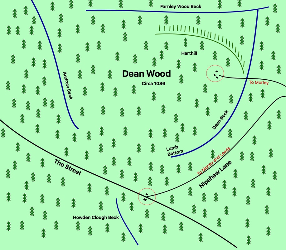
Dean Wood circa 1066. With hypothetical activity at Nipshaw and Harthill.
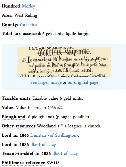
Morley in the Domesday Book
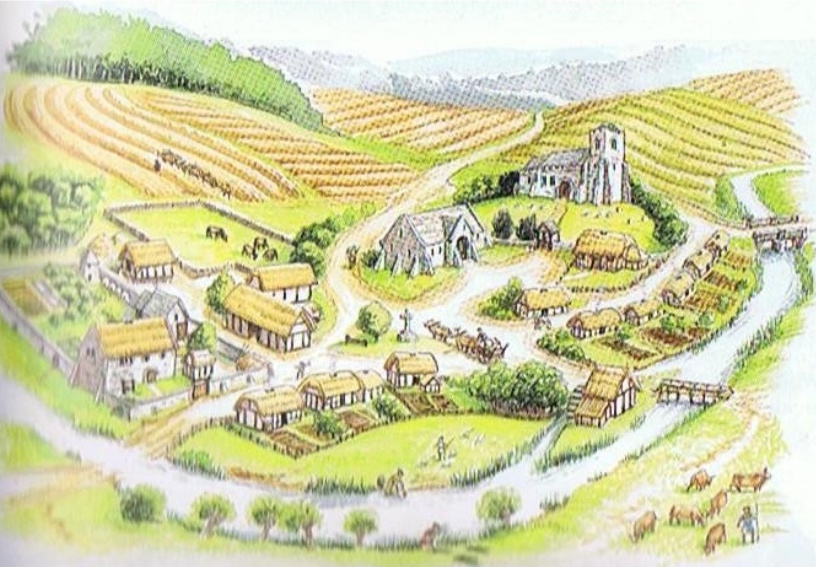
Medieval Morley could have looked something like this village, with the Church on the hill, the Demesne to the left and the Hall in the center.
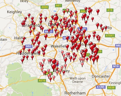
Ilbert de Lacy's holdings in Yorkshire 1086
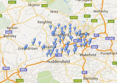
Wapentake of Morley 1086 - 56 Manors
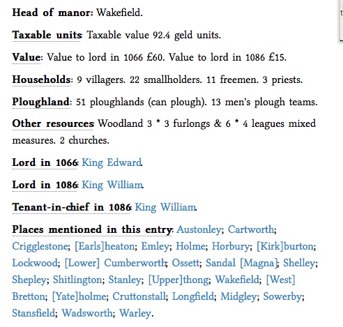
Wakefield Manor in the Domesday Book
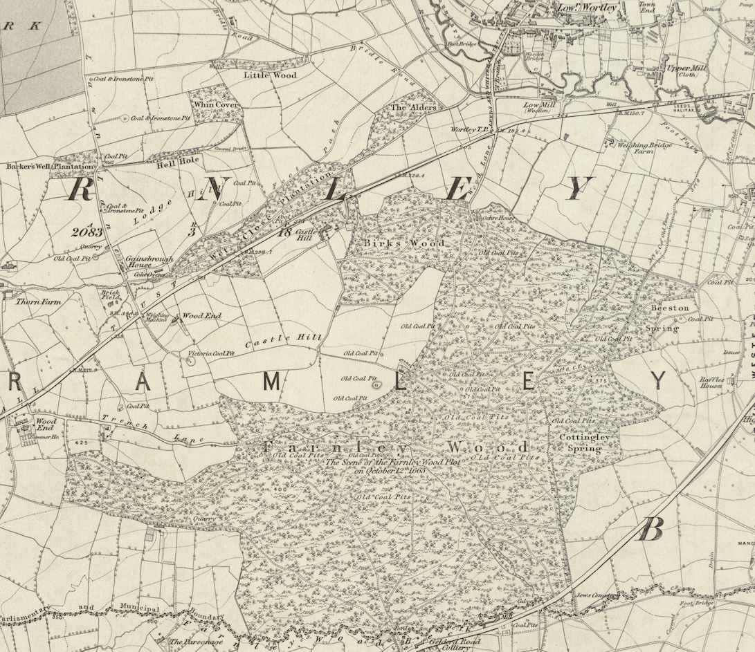
1852 Map showing the extent of Farnley Wood
|
Dean Wood
As previously mentioned, the name Dean Wood is used to describe the area now known as the district of Gildersome as it was in 1066. That is all the land within the boundaries of Dean Beck, Farnley Beck, Andrew Beck and the headspring of Howden Clough, with Hart Hill being its most prominent feature. In 1066, it was a thick woodland, mostly untouched. We know this because of a 13th century text that mentions the "assart of Gildus", and specifically pinpoints it just south of Farnley Wood Beck. Philip Henry Booth in his History of Gildersome wrote: "In the Coucher Book of Nostell Priory, according to Sheard, the boundaries of the parishes of “Batelay” and Leeds are described as “a certain river descending between the wood of Farnley and the assart of Gilders as far as the hospital of Beeston.” The hospital of Beeston was founded in 1322, and as the word “assart” means land cleared of wood, we may take it that in the 14th century there was land cultivated in Gildersome. Sheard’s rendering of the entry is a little different from Scatcherd’s."
William Smith, in his book, 'Morley Ancient and Modern', wrote the following about what has remained of Dean Wood:"In the field beyond the site of Holliday's pit is the pathway leading to Gildersome through Dean Wood, the last-named being of considerable extent, and would doubtless at the time of the Conquest include the smaller copses known as Daffield Wood, Clubbed Oakes, and Clark Springs, which extended east and west down to Beeston. The name Dean or Den is a very common one. BARDSLEY says that " a den was a sunken and wooded vale, where cattle might find alike cover and pasture." In this way den came to be spoken of in connection with animal life ; and we find the ram in Ramsden, the swine in Swinden, the wolf in Wolfenden, and the hog in Ogden. At one time, Morley would possess, in common with many other Yorkshire villages, that important public official known as the " swine-ringer." These men did not ring the pigs themselves, but the prerogative of the office was to see that no pig was allowed upon the common without one strong nail, at least, being firmly embedded in its nose. In those days there were no hedges, making separate enclosures of fields, but plenty of woods. Every foot of ground was not then marked out and held by individual freeholders. There was a common-right ; that is to say, every native householder had free range for his horse, or cow, or pig. The name "Dean" has many other significations, as Den (A.S.) a forest or outlying pasture in the woods; Den (Celtic) a small valley or dingle. Names of places ending in den (neuter) always denoted pasture, usually for swine. Another authority says that " the term dene or dean in its local acceptation indicates a narrow wooded valley, whose Tradition has connected Dean Wood with a ferocious sow, the terror of many youngsters, more than fifty years ago, who durst never go through the wood alone for fear of the " Dean Sow," as it was called. The styes, which were placed in unsavoury proximity to most of the cottages in Morley, were only used as sleeping places for the swine, which were driven to and fro, to Dean and other woods, by the Seniors or swineherds of former generations, and in later times by happy youngsters, who whiled away their time in bird-nesting or nutting."
|
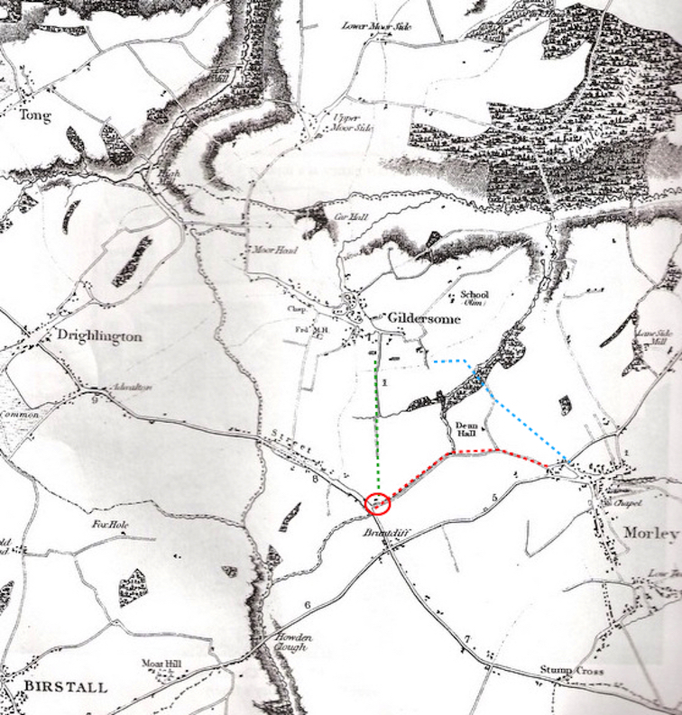
Right is an 1822 map of Gildersome and its surrounding region before Gelderd Road. Dean Wood's extent in 1822 seems to be similar to what remains today. In 1066 it was part of a forest that covered the map.
The red dashed line depicts "Neepshaw" Lane, now called Nepshaw Lane. The blue line is an ancient route from Gildersome to Morley through Dean Wood, using the footpath bridge shown above. The green line is another old entrance into Gildersome begining at the intersection of Nepshaw Ln. and the Street (Red circle). The road to Bruntcliffe and then through Howden Clough didn't exist in the early middle ages. |
Click on map to expand.
|
 Neepshaw Ln and Bruntcliffe Ln from Lord Dartmoth's map of Morley, circa 1780. Click to Expand.
"Neepshaw" Lane
If the quote "Location, Location, Location" applies to prime real estate, it would then apply to Dean Wood, which encompassed the intersection of the Street and the Leeds to Manchester Road. So it was that from Dean Wood one could have direct access to the main roads leading to Leeds, Halifax, Manchester, Bradford and Wakefield, as well as all towns and villages in between. Today, that intersection can be found where Nepshaw Lane joins with the Street. Back then, Nepshaw Lane had significance as a section of the main road from the Street to Leeds via Morley Hole. This was centuries before the road through the Spen Valley, via Bruntcliffe, took over as the main thoroughfare. Though shorter, the Bruntcliffe route was much steeper, back in the days of oxcarts and dirt roads, this made a big difference, especially when muddy. This makes sense if one considers that the gradient of Nepshaw Lane, between Morley Hole and the Street, was a difference in elevation of 90 feet, compared to Bruntcliffe Lane which was 140 feet. After the turnpike system came to the area, circa 1730s, and wagon and road technology improved, the Bruntcliffe route stole Nipshaw's traffic. Nepshaw Lane continued to be used as an alternative to Bruntcliffe but its traffic continued to diminish until the late 19th century severed it in two and condemned it to obscurity as an insignificant country lane.
Norrison Scatcherd, in his 1823 'History of Morley' said this about Neepshaw Lane: "I would just state that the road from Leeds to Manchester in these times, was as follows : — First, through Beeston to " Morley Hole." and up Neepshaw-lane to the "' Street," or Roman road (extending from about Bradford to Castleford, as hereafter will be mentioned) ; next, along this road, till it reached Adwalton. It then was left, and the way was over Adwalton-moor, down " Warren's-lane," past "Oakwell," and up to Gomersal. This also, was one of the ways, perhaps the only one, to Halifax."
Whether the Street was a Roman road or not is still open to debate, however, there's no doubt that the roads in 1066 were ancient and little better than a set of parallel ruts. Taking goods to far off markets could be laborious work made worse in bad weather. From Dean Wood, the best markets were found at Leeds, 5 miles away, and Wakefield, 8 miles off, as both had access to river trade. In the middle ages transporting merchandise to these towns could take all day, if not longer. And, dangerous as well. Dean Wood and Farnley Wood beyond, must have been a perfect location from which marauders could pounce upon unsuspecting travelers, then disappear quickly back into the forest.
Next: Medieval Gildersome